

[CODE_4]: MEDIA_ELEMENT_ERROR: Format error


 חלקי חילוף בחינם
Items | Specification | ||
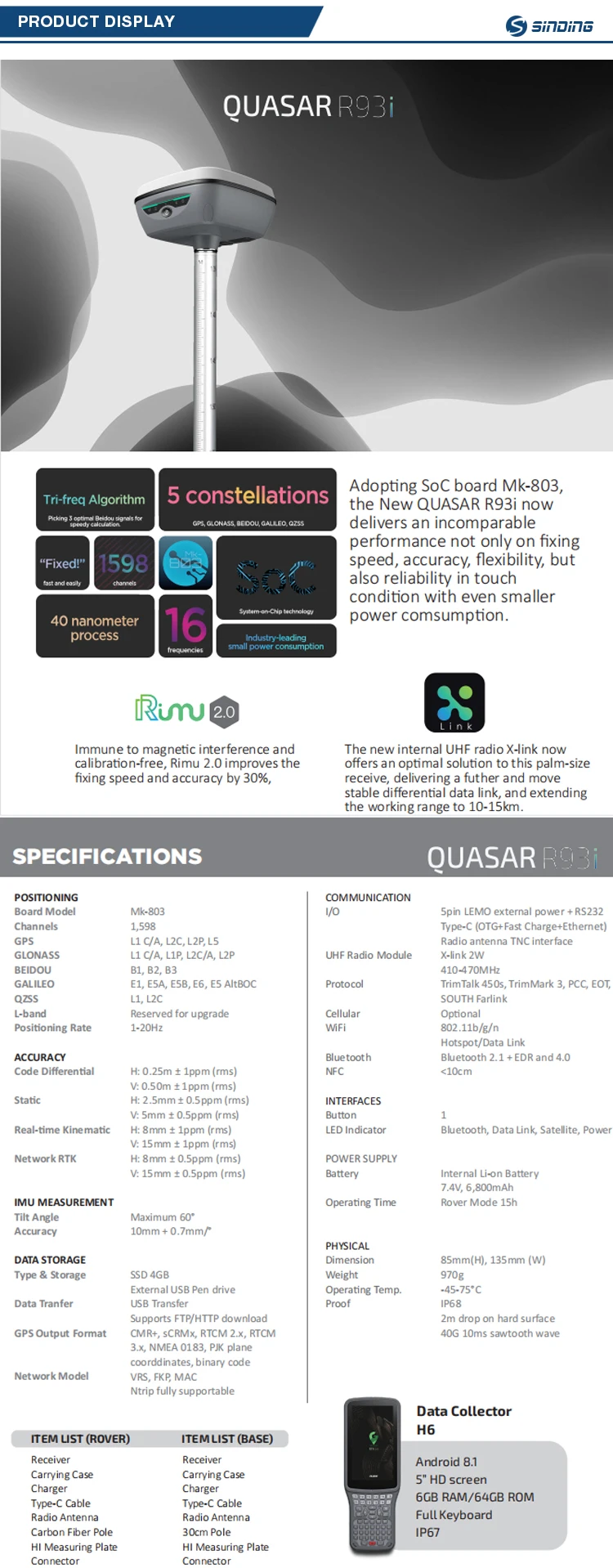
GNSS | Signal Tracking | 1598 Channels | |
BDS:B1,B2,B3 | |||
GPS: L1,L2C,L2P,L5 | |||
GLONASS: L1 C/A, L1P, L2C/A, L2P | |||
Galileo: E1C,E5A,E5B | |||
SBAS,QZSS: support | |||
L-Band :support | |||
GNSS Features | Positioning output rate 1Hz~20Hz | ||
Initialization time : <10s | |||
Initialization reliability : >99.99% | |||
All-Constellation receiving Technology that supports all existing and planned GNSS constellation signals | |||
Positioning Precision | Code Differential GNSS Positioning | Horizontal:0.25 m + 1 ppm RMS | |
Vertical:0.50 m + 1 ppm RMS | |||
SBAS positioning accuracy: typically <5m 3DRMS | |||
Static GNSS Surveying | Horizontal:(2.5mm+0.510-6D) | ||
Vertical:(5mm+0.510-6D) | |||
RTK Surveying | Horizontal:(8mm+110-6D) | ||
Vertical:(15mm+110-6D) | |||
Operating system / user interaction | Operating system | Linux | |
buttons | Single button operation, convenient and quick | ||
indicator | Four indicator lights | ||
Web interaction | Built-in WebUI management background, support WiFi and USB mode access WebUI page, real-time monitoring of receiver status, set any configuration of the receiver. | ||
voice | Intelligent voice technology, support for Chinese, English, Korean, Russian, Portuguese, Spanish, Turkish; support for voice customization | ||
Data cloud service | Support register online, remote upgrade and etc. | ||
Electrical | Power | 9-28V wide voltage DC design with overvoltage protection | |
Battery | High capacity built-in battery 6800mAh 7.4V | ||
Power solution | Routine operations meet the endurance of more than 8 hours | ||
(Provide 7*24h continuous working power solution) | |||
Communications | I/O Port | 5 PIN LEMO External power interface +RS232 | |
7 PIN LEMO with USB(OTG) | |||
Radio, Network Antenna Interface (shared) | |||
Radio modem | Built-in high performance radio, | ||
operating frequency 410-470MHz, | |||
External radio: 5W/25W/35w | |||
protocol: TrimTalk450S,TrimMark3, SOUTH, CHC,SATEL,HI-TARGET | |||
Blue tooth | BLE blue tooth 4.0;blue tooth 2.1 + EDR standard | ||
NFCwireless communication | Using NFC wireless communication technology, the controller can be automatically paired with the receiver.( controller needs have NFC wireless communication module) | ||
WIFI | standard | 802.11b/g/n | |
WIFI hot spot | WIFI hot spot function: intelligent terminal can connect to the receiver to do personalization custom; | ||
Data transmission supported between the receiver and the controller | |||
WIFI data chaining | Receiver can access WIFI, to broadcast or receive differential data via WIFI | ||
Data storage / transmission | Data storage | 8G solid state memory, supporting 32GB external extension, Automatic cyclic storage, | |
Supporting external USB memory for data storage; | |||
transmission | One key Smart copy directly exports host static data via external USB memory; plug and play USB for data transfer; FTP download, HTTP download. | ||
data format | Static: SOUTH, Rinex2.01, Rinex3.02 and etc. | ||
Differential data format: RTCM 2.1,RTCM 2.3,RTCM 3.0,RTCM 3.1,RTCM 3.2 Input and output; | |||
GPS output data format: NMEA 0183, PJK plane coordinates, binary code, | |||
IMU/Sensor | Electron bubble | Built-in sensors, data collector software can display electronic bubbles, real-time check the alignment of the surveying pole leveling situation | |
Shake and shake tilt measurement (optional) | The built-in IMU sensor supports the tilt measurement function of shaking and shaking, and automatically corrects the coordinates according to the tilt direction and angle of the centering rod. | ||
temperature sensor | Built-in temperature sensor, real-time monitoring and adjusting host temperature | ||
Physical | Size | 135*135*84.75mm | |
Weight | 0.97KG with battery | ||
Material | aluminium magnesium alloy | ||
Temperature | Operating:0°Cto +65°C | ||
Storage:0°C to +80°C | |||
Humidity | Resistance to 95% condensation | ||
Waterproof/ Dustproof | Waterproof:1m immersion,IP68 | ||
Dustproof: Completely prevent dust from entering,IP68 | |||
shockproof | Resistance to 2-meter drop with rod | ||


תוכלו לצפות שההזמנה שלכם תסופק לפני התאריכים המתוכננים או שתקבלו פיצוי בשווי 10% על העיכוב

כל תשלום שאתם מבצעים ב-Cooig.com מאובטח על ידי הצפנת SSL ופרוטוקולי PCI DSS קפדניים להגנה על נתונים

דרשו החזר כספי אם הזמנתכם אינה נשלחת, אובדת או מגיעה עם בעיות במוצרים